Wind Analysis using ArcGIS Data
Airflow Analyst can utilize general GIS data such as topographic data and building shape data for wind analysis.
This is extremely efficient because the model data can be used directly for simulation without any conversion or re-modeling of the model data, which conventional fluid analysis software requires.
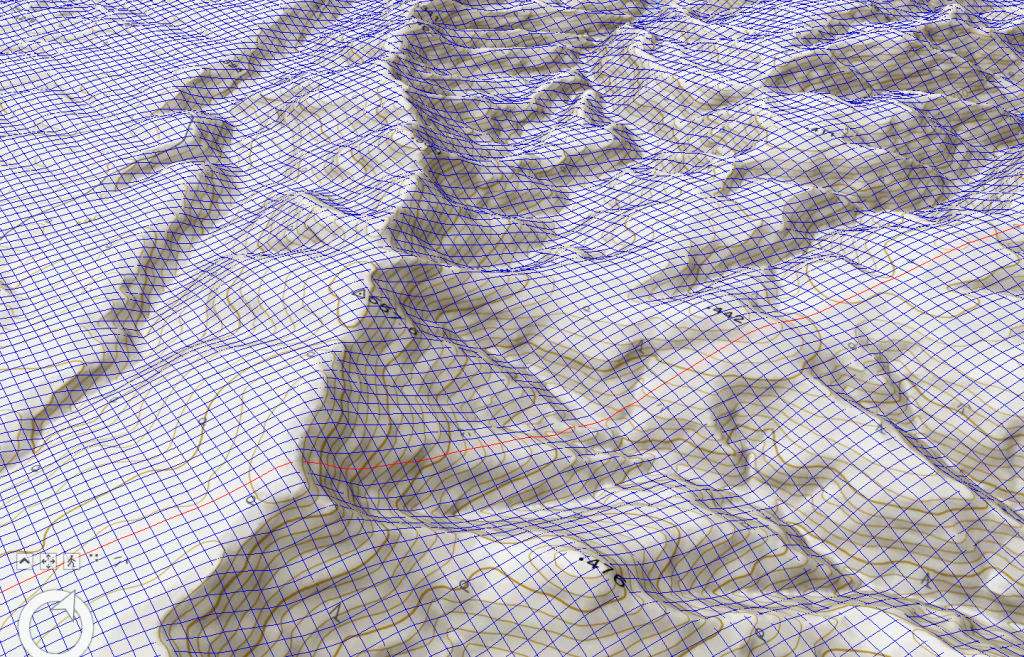
Elevation Data
The worldwide elevation data distributed as standard in ArcGIS Pro can be used for terrain data. This eliminates the need to prepare new data when analyzing airflow over terrain.
Satellite imagery and DEMs generated from drones can also be utilized if original terrain data is desired.
Building Data
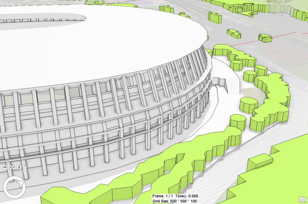
For buildings, a variety of data supported by ArcGIS Pro is available.
This includes (1) polygon data including height information, and (2) multi-patch feature classes.
It is also possible to combine and analyze various data, including open 3D data such as PLATEAU, commercially available 3D data such as AW3D, BIM/CIM design data, 3D data created by 3D modeling software, and urban area data created by ESRI City Engine.
These features make wind analysis more efficient and accurate.
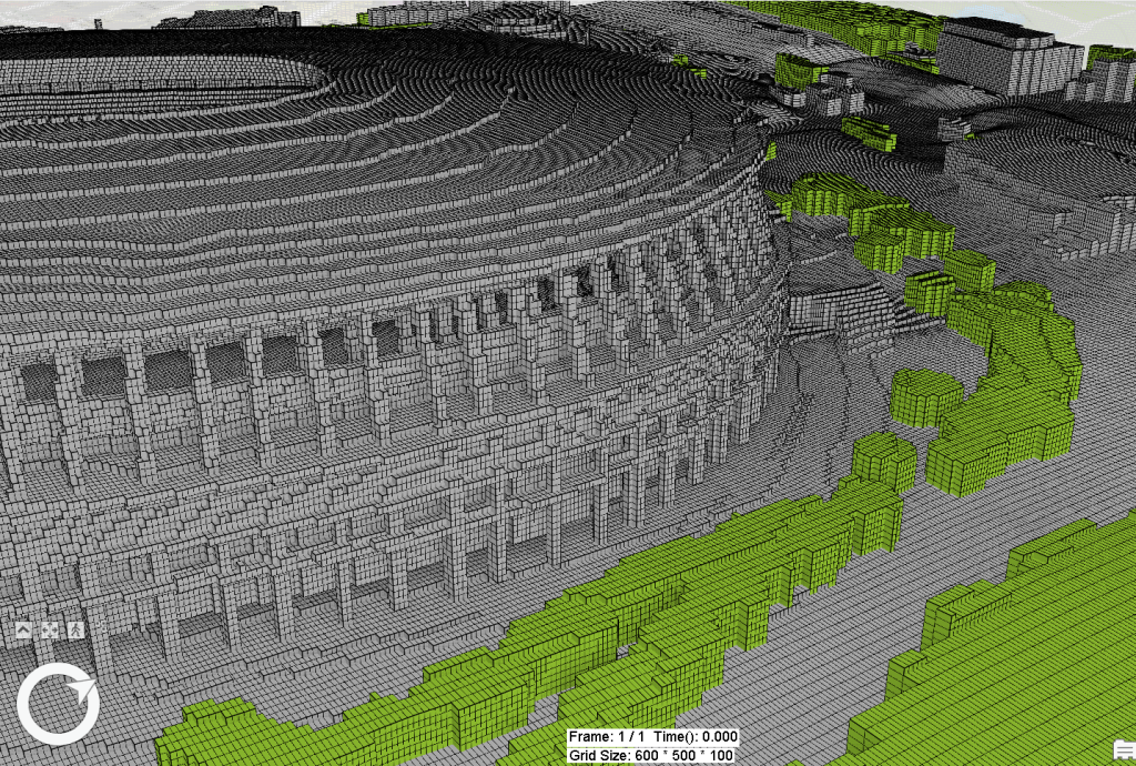
Generation of Computational Grids through an intuitive Operation
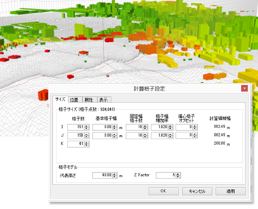
A three-dimensional “computational grid” is created in wind simulations. This computational grid’s fineness directly affects the simulation results’ accuracy.
Airflow Analyst features a 3D view of the computational grid being created by the user on a map. In addition, this grid can be changed interactively according to the user’s preferences.
This allows the user to intuitively set the range of the calculation area and the fineness of the grid spacing relative to the terrain and landforms while confirming the settings in 3D. This allows for more precise wind simulations with the user’s intended settings.
Advanced Unsteady Analysis with LES on a Personal Computer
Airflow Analyst employs a Large Eddy Simulation (LES) solver that can faithfully simulate complex wind dynamics over time.
Generally, LES takes a lot of time to compute, but Airflow Analyst’s LES is optimized for multi-core CPUs so that results can be obtained on a typical personal computer in a few hours.
If a PC is equipped with a GPU, which excels at even faster calculations, the calculation speed can be several times faster than that of a CPU.
This allows for rapid identification of wind movement and allows designers to concentrate on designing and formulating solutions to wind-related problems.
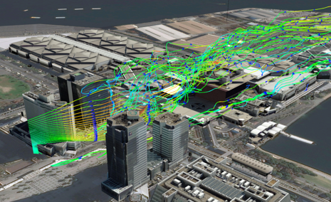
Scientific Fluid Visualization Techniques on ArcGIS Pro
A unique extension of ArcGIS Pro 3D’s display capabilities allows various visualizations of fluid flow phenomena.
The display area can be interactively manipulated and displayed in 3D animation. This allows for a very intuitive understanding of the flow structure and presentation on the map.
In addition, statistical processing and conversion to feature classes can be performed on the analysis results.
This allows users to use ArcGIS’ powerful spatial analysis methods to make decisions and output them as maps for communication.
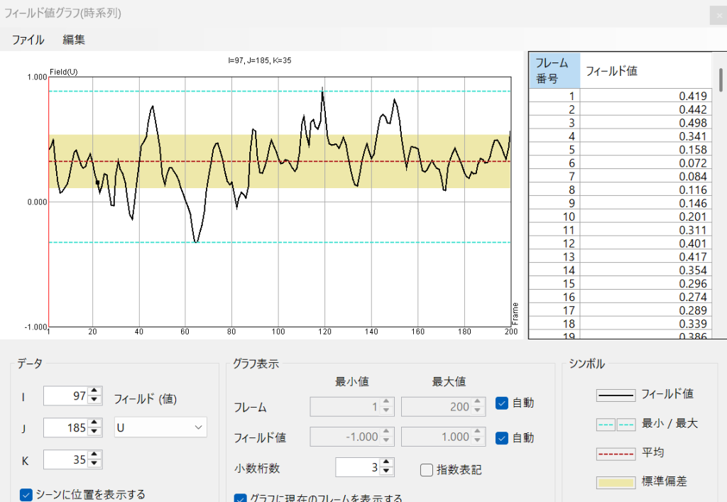
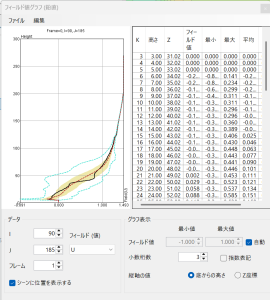
Statistical Processing Function for Wind Simulation
Fluid analysis results are unsteady analysis that varies over time.
It enables statistical processing of time-series data to quantitatively evaluate quantities that vary with time, such as wind speed and gas concentration.
In a later stage of the simulation, the mean, maximum, minimum, and standard deviation of various variables (wind speed, gas concentration, etc.) at each grid point can be calculated and output as statistical processing.
This allows for a clearer understanding of changes through time.
Simulation of Air Permeability
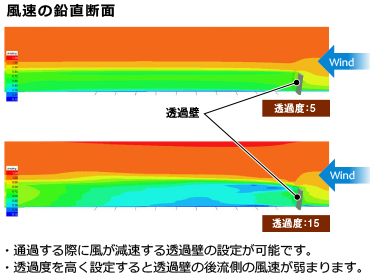
Trees and windbreak nets have the property of weakening and transmitting wind.
Airflow Analyst can simulate the effect of transmitted wind by assigning the properties of this transmission wall to the geometry on the map.
As a result, simulations can consider how plantings and wind nets affect the wind environment.
This allows for a more realistic assessment and analysis of the wind environment.
Airflow Analyst Trial Download
Trial period: about 1 month
Difference between the trial version and the full version:
There is a limit to the number of grids that can be calculated.
Operating conditions:
・ArcGIS Pro 3.0 or higher
・OpenGL graphics board
・12GB memory or more recommended